


In graduate school, one of the authors took a class on the phases of human development. The professor emphasized that it was the transition between the phases that was more important than the phases themselves. The transition into a new job, relationship, home, etc., was very influential to what came next. In architecture, these transitions are often called liminal spaces - that which lies between.1
In weather, the boundary layer is the interface between the atmosphere and the surface of the planet. It’s down low in the sky, where most of the interesting stuff happens because it’s what impacts our daily lives.
Studying the interaction between the earth and the sky during extreme events like tornadoes can be challenging. They tend to be shy and unpredictable. Obtaining traditional direct wind speed measurements using anemometers is nearly impossible in the most intense parts of violent tornadoes. It is exceedingly rare for anemometers to be in the exact right place at the exact right time, and even if they were, they would likely be destroyed by flying debris. Therefore, other methods, including damage assessment and Doppler radar measurements, are used to determine wind speeds in the most intense parts of violent tornadoes.
However, radar still tends to underestimate tornadic wind speeds, even if used in extremely close proximity. Here are five reasons, one for each finger of the hand:
In tornadoes, radars measure the speed of airborne debris, which typically moves more slowly than the wind.
Radars measure the average velocity of objects in volumes, not at precise points. Therefore, peak measured velocities are less than those occurring at individual points in these volumes.
Doppler radar only measures the component of the wind velocity towards and away from the radar source, using algorithms to estimate sideways motions.
Peak wind gusts determined using Doppler radar measurements may occur for different durations at individual locations. Wind gusts can be <1 second in duration and missed by a large radar pulse.
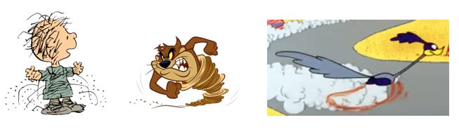
Because the Earth is curved, wind measurements are increasingly higher above the surface as the reflection moves farther from the radar. Research has shown that those speeds are usually slower than those at the surface itself (see the Tasmanian Devil for a fancy scientific illustration).
Getting Up Close and Personal
Obtaining quality data about tornado behavior close to the ground requires getting mobile radar units within a few miles of a tornado, a difficult and dangerous assignment. But folks are getting better at it thanks to skills that can only come with years in the field.
In a groundbreaking article in Nature Communications, Dr. Karen Kosiba and Dr. Josh Wurman described how they measured the surface wind speeds of 73 different tornadoes by using a mobile radar system from the Flexible Array of Radars and Mesonets (FARM) , which operates the Doppler on Wheels (DOW) fleet of vehicles. Being mobile, they can respond rapidly to changes in a storm’s trajectory. And with that closer proximity, the DOW radars can scan at lower altitudes and higher frequencies. Better data = better science.

Enter Storm Chasing
The DOW team deployed during four tornado events the week of May 20-26, 2024 for the National Science Foundation (NSF) supported BEST project. Along with them was Jen Walton, founder of Girls Who Chase.2 One of those events was the Greenfield, Iowa, tornado on 21 May 2024.
“I’ve been storm chasing for seven years, and have a background and training as a wildland firefighter and Public Information Officer. When you choose to drive toward a natural disaster vs. away (like a normal, reasonable human) there’s a certain level of risk. While chasing the high plains, I had blessedly only witnessed severe weather causing minimal damage (like power lines down, pivot irrigations flipped, etc.).
When I joined the FARM Facility for the BEST project this season, I knew that my days of finding relative peace with tornadoes were numbered. Eventually my time would come and I’d have to reconcile my fascination with things that spin, with how they impact lives and property. That day arrived on May 21, in Greenfield, Iowa.
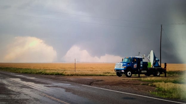
The day started how chase days often do – hanging out at a Casey’s, slice of pizza in hand - but very quickly progressed into a fast-paced chase to maneuver ahead of a line of storms that all began producing tornadoes in rapid succession, and were moving at 45mph or more. That day, I was riding in the navigator seat of SCOUT3 – a truck equipped with multiple pods (including anemometers) designed to be dropped in the path of an oncoming tornado. As our trajectory was clearly about to intersect tornado #3 of the day, we were traveling east on highway 92, which passes through Greenfield. The team deployed DOW6 on the west side of town, and DOW8 and SCOUT3 continued through Greenfield to the east side, the tornado coming toward town from the southwest. DOW8 deployed and SCOUT3 was sent back toward town to drop pods. It was clear almost right away we weren’t going to make it through town with the tornado roaring northeast toward us; we chose a spot just east of the center of town, and with debris raining down on us, deployed one pod, took GPS coordinates and fled back east.
We now know that the location of our deployment was roughly a half-mile from the center of a 100m-wide drill bit that has been classified as an EF4+. That day was my first time in Iowa, my first pod deployment, and my first up-close experience of the destruction caused by a tornado seriously impacting a populated area.
Nothing can really soften the experience of seeing property decimated and learning that an event you were present for was fatal (five people died in the Greenfield tornado). And yet – that’s exactly why we were there. I participated in a rapid, well-executed, multifaceted deployment designed to assess exactly how tornadoes do this kind of damage so we can help prevent future risk in a variety of ways. It doesn’t exactly make it easier, but it helps."
DOW scientists calculated peak wind speeds as high as 309-318 mph (!) in a narrow region on the right side of the tornado (in the direction of motion). Since the tornado was very small and fast-moving, these peak winds were likely experienced for less than a second at specific locations in the town. These are among the highest wind speeds ever measured using DOW data.

Various versions of DOWs have been in operation for almost 30 years. This was only the second time they got this close to a tornado in this densely populated area (the other time being in 1998). That’s how rare and challenging this work is. By being near such an area, they are able to study the relationships between their wind speed measurements and the actual damage that occurred.
Two days later, on May 23, they were chasing in Oklahoma when they deployed near the Duke/Olustee tornado. Below is footage of the DOW vehicle in action in front of the tornado's actual structural formation. Click to watch this time-lapsed video to see a tornado form right before your eyes.

More from Jen on what it was like that day on the front lines:
“That storm was truly fascinating to watch; it formed and then began to nibble on a boundary, essentially remaining completely stationary while it pondered its future. While it did that, DOW6 deployed in the forward flank and DOW8 traveled south and east to deploy, sending SCOUT3 and Swarm van (a van equipped to put swarmsondes via balloon into a storm’s inflow) into the notch.
When it did eventually begin to move, it was rotating hard and put down the first iteration of multiple types of tornadoes (cone, stovepipe, etc.) fairly quickly. You’ve seen tornadoes, but have you ever “seen tornadoes from the front seat of a DOW” seen tornadoes? 10/10 recommend, would do again. It’s not the same perspective as storm chasing (obviously), but getting a front-seat view PLUS getting to watch it evolve at the same time in high-detail radar data is insanely cool. We were able to capture the entire lifecycle of the tornado(es), remaining in place and scanning for almost two hours!”
Happily, multiple research organizations now have mobile radar units (ex: RaXPol and NSSL). Many are saying the Duke tornado was possibly one of the most-researched tornadoes ever (the other being Goshen, Wyoming way back in 2009 during VORTEX2). The lower regions of tornadoes are on their way to being better understood.
And Now for Something Completely Different
Can Mars affect Earth’s climate? Geologists from the University of Sydney in Australia and the Sorbonne University in Paris analyzed sediment cores drilled from the ocean floor to measure changes in the planet’s climate over the past 65 million years.
They discovered a climate cycle in which the Earth warms up slightly every 2.4 million years, matching an orbital resonance between Earth and Mars. Their theory is that Mars's gravity changes the shape of Earth’s orbit (its eccentricity) just enough to occasionally bring more sunlight to Earth, thereby warming it. This warming causes ocean currents to shift, which is what they detected in their core samples.

I’m usually skeptical of such correlations, but this was published in Nature Communications, a highly esteemed publication. And the scientists published their data for all to access, in the best spirit of scientific transparency.
We acknowledge additional contributions from Dr. Karen Kosiba and Dr. Josh Wurman from the NSF BEST team (National Science Foundation award #2242212).
The mystery of liminal spaces makes them a popular area for horror, sci-fi, and fantasy films. For a classic example, check out Hayao Miyazaki’s Spirited Away.
 | A guest post by
|