


Breaking: Let's Drive into a Hurricane
Raygun has nothing on this breaking news

We try not to cover the news here at WWAT because there are others who do that better (pretty much everyone). But this is a unique situation. The Doppler on Wheels (DOW) team is planning to deploy into Hurricane Helene. We have since covered the DOW research team multiple times, so we feel like they are a part of the WWAT family. And this could be interesting.

We usually think of the DOWs being deployed to study tornadoes. Having radar and other measurements close to the tornado allows researchers to collect data closer to the surface and at higher time and spatial resolution.
But they also deploy to hurricanes. In 2017, the team studied Hurricane Harvey and published this open-access paper describing their results. They focused their research on persistent tornado-scale vortices (TSVs) and eyewall mesovortices (MVs) in the hurricane boundary layer (there’s that word again).
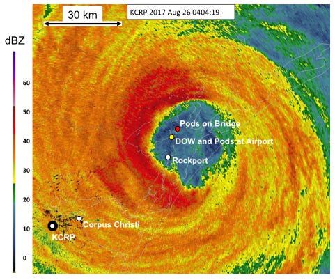
Eyewall mesovortices are small-scale, intense rotational features within a tropical cyclone's eyewall. The eyewall is the ring of thunderstorms surrounding the eye of the storm, where the most severe winds and vigorous convection occur. Tornado-scale vortices are similar but smaller in scale and can form within an eyewall or outer rainbands. These vortices are usually similar in intensity to EF0-EF3 tornadoes. They are fairly rare1 and mostly associated with intense and strengthening hurricanes. Thus far, DOWs have deployed to 14 hurricanes and only measured MV/TSVs in two.
Their work was the first direct evidence of the impact of MVs and TSVs on wind speed and associated damage caused by hurricanes. In particular, they learned about their effect on the already strong background winds in an eyewall. This can help improve forecasts and models of wind damage in hurricanes.


A Live Free Discussion with the DOW Team on Sept. 26.
Our parent organization, the American Meteorological Society, runs a network of weather enthusiasts called WeatherBand. They are planning a live webinar on the DOW deployment on Thursday, September 26 at 3 pm CT. Key researchers from the DOW team will attend, including Jen Walton from Girls Who Chase. More info is below:
Tropical Storm Helene is projected to intensify into a (potentially major) hurricane and make landfall in Florida this Thursday. Josh Wurman and Karen Kosiba from the Doppler on Wheels (DOW) project aim to be in the thick of the storm gaining valuable ground-level weather data. They will join us from their Doppler-equipped vehicles (which also venture into the paths of tornadoes and other severe weather) to discuss what they are seeing as the hurricane unfolds. The discussion will be moderated by Jen Walton, DOW team member and founder of AMS partner organization Girls Who Chase.

About AMS WeatherBand

The AMS Weather Band is a global community of weather enthusiasts eager to learn and share their passion for weather and science. Participants gain cutting-edge insights from the American Meteorological Society, which has been at the forefront of weather research for over a century. The Weather Band connects professionals in the weather, water, and climate community with enthusiasts and students, offering experts the chance to engage with a broader audience. Activities include virtual events, online discussion boards, photo contests, AMAs, webinars, and more.
Weather Band participation is entirely free. Click for more info.

Our best wishes for a safe deployment to Jen, Josh, Karen, and their team. And for all the communities affected.
More information about the DOWS can be found in this prior WWAT article:

However, this could be due to a selection effect. They could seem rare because they are difficult to measure. Anemometers rarely survive eyewalls.
Those DOW's sound very daring. I hope they take all due precautions!