One of WWAT’s earliest issues was about the formation of rain, snow, and hail in clouds. It was tough to put together. It usually takes about 3 hours to write a newsletter. That one took about six. This was me when I sent the first draft to the advisory board:
This was me when I got their edits back:
Was Bill the Cat drunk, or did he recently write an article about cloud condensation? For that matter, what would a drunken cloud look like? Because no one else was home, I asked ChatGPT.
Clouds don’t just form out of thin air. There are certain prerequisites for those little fluffy clouds. They need the right temperature, air pressure, relative humidity (sigh - that again), and an aerosol particle for water vapor to condense onto or freeze around. These aerosols are tiny bits of particulate matter, either biological (like microorganisms or fungal spores) or mineral (such as dust, sea salt, or ash). Some aerosols even come from space. And, sadly, some come from pollution (mostly carbon and sulfates). That last bit is increasing over time, so scientists are keen to learn more about how that will impact cloud formation and thunderstorm development.
Isolated Deep Convective Clouds
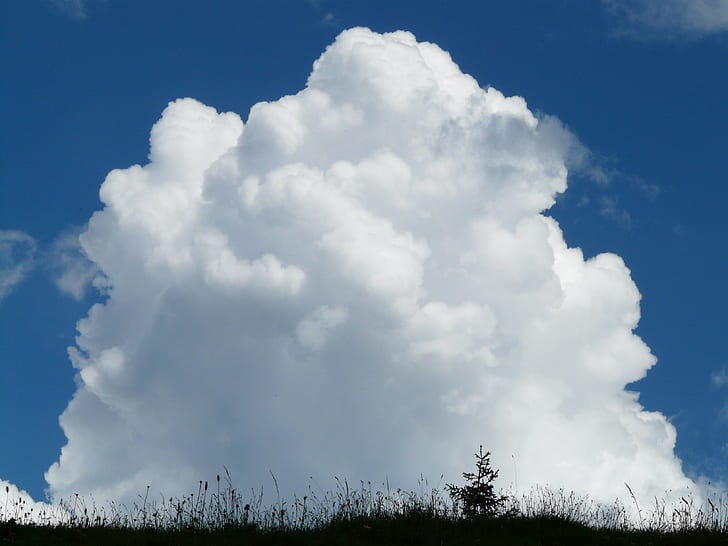
Isolated deep convective clouds (DCCs) are clouds that are not part of a pre-existing large cloud system (“isolated”) while also being quite tall (“deep”) and growing due to rising parcels of heated air (“convective”). These clouds are common in warm, humid air masses and can produce quick-forming, short-lived thunderstorms. Think of the brief afternoon storms that often pop up and then disappear in the tropics.

Scientists are interested in how increasing aerosol concentrations might affect clouds like DCCs. There are two dominant theories in the field. One suggests that more aerosols will lead to increased rainfall by providing additional nuclei for cloud droplets to form, grow, and eventually fall as rain. The other proposes the opposite: that higher particle concentrations create more competition for water vapor, resulting in smaller cloud droplets, some of which may never grow large enough to fall as rain.
Radar Love
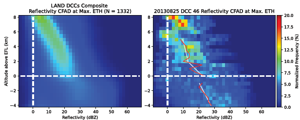
A research team led by Jonah Pehlt (University of Oklahoma) recently published an article in the Journal of Atmospheric Sciences describing results of a project to study the influence of aerosols on DCCs using 8 years of radar data. They used archived dual-polarization radar data from ~1300 DCCs tracked by the sweet KHGX WSR-88D radar near Houston, TX from 2013 – 2021.
Each storm is different. The researchers needed to account for as many other variables as possible, so when they combined data, it’s more like apples-to-apples than apples-to-oranges. One way they did this was by focusing on DCCs that formed in seabreeze environments over land. These tend to be more consistent than, say, DCCs that formed due to frontal passages or tropical disturbances. They also included data from the ECMWF ERA5 weather database to characterize atmospheric conditions around each DCC.
The ERA5 is kinda of amazing. It’s a database that estimates the weather all over the earth from 1950 until now (or very close to now - it’s continually updated). It has a grid resolution of around 51 km (~32 miles) and provides variables related to 137 different levels of the atmosphere up to an altitude of 80km (~50 miles). ERA5 is kind of like the Ken Jennings of meteorological databases. It can tell you anything you want, if you ask the right question.
With the ERA5 data they documented the meteorological conditions around each DCC. Now they need to look at the DCCs themselves. With so much data, this needed to be automated. They used the Multicell Identification and Tracking (MCIT) algorithm originally designed by Hu, et al. (2019). MCIT automatically detects and tracks individual thunderstorm cells using archival radar and lightning data.
DCCs evolve over time, so to ensure a consistent comparison, the researchers focused their analysis on the point when each cloud was at its strongest. This typically corresponds to when the storm reaches its maximum height. This is reflected1 in radar data as the echo top height.
So now they have the surrounding environmental conditions, the times of peak storm conditions, and radar scans. Something is missing - the aerosol data! For that they turned to the MERRA-2 database, focusing on anthropogenic aerosols (organic carbon, black carbon, and sulfate) since these are most relevant to cloud microphysics2. The researchers categorized aerosol environments as “high” or “low” aerosol loading based on the MERRA-2 data from within meteorologically similar conditions.
Pollution Leads to Ice
The results are in. There is a clear winner, but with a caveat.

In high aerosol conditions, DCCs tended to exhibit weaker rain signatures and stronger signals of ice and freezing processes. This supports the theory that additional aerosols inhibit rain formation by limiting the growth of cloud droplets. These smaller droplets can be carried higher into the atmosphere by updrafts, where they cool and sometimes freeze. Pollution may lead to less rain but more hail, though the overall impact is heavily influenced by other environmental factors.
The differences between low and high-aerosol environments were most pronounced under dry tropospheric conditions and high atmospheric instability (as measured by CAPE). In dry conditions, the high-aerosol DCCs showed stronger evaporation signatures below the freezing level and more signs of condensation and freezing above it. Under high instability, aerosol-influenced DCCs exhibited more freezing and melting signals in the mixed-phase region but didn’t necessarily produce more precipitation.
Under moist or low-instability environments, the aerosol effects were less dramatic. While some suppression of rain and enhanced vapor deposition was still evident, the differences were smaller and less statistically significant. These results highlight that while aerosol loading can influence cloud microphysics, the meteorological environment strongly modulates how those effects manifest. The paper goes deeper into the relationships with many specific environmental variables such as tropospheric humidity, freezing levels, precipitable water, and much more.
Side note: The paper has a Table that describes all the acronyms used in the manuscript. Hallelujah! I’ve never seen such an academic Rosetta Stone before, and it is brilliant.
These findings show that aerosol pollution can influence how clouds develop and produce rain - and that these effects are closely tied to specific meteorological conditions. They also provide observational evidence to help evaluate two competing theories of aerosol–cloud interactions. It’s a nice example of real-world data advancing science theory.
And Now for Something Completely Different
The Tuskegee Airmen were the first Black military aviators in the U.S. military. They flew over 15,000 missions above Europe and North Africa in World War II. They received the Congressional Gold Medal from President Bush in 2007.
But they couldn’t have done it without the Tuskegee Weather Detachment, who were, ironically, attached to the airmen during their combat operations. Wallace P. Reed, a recent MIT graduate specializing in applied meteorology, led the group. He later became the first Black meteorologist in the U.S. Weather Bureau (now the National Weather Service).

Kelly V. Porter writes more about the Tuskegee Weathermen in her Bios and Backstories Substack newsletter. She has a close attachment in that her father was a member of the generation of meteorologists in the United States mentored by the Tuskegee Weathermen.
We acknowledge additional contributions from Chris Nabholz. We are grateful for a grant from Lockheed Martin to support this newsletter.
Our archive of WWAT articles is here.
During the preparation of this work the author(s) used ChatGPT-4o in order to copy edit text, create the cloud cartoon, and explain some of the paper’s results. After using this tool, WWAT’s author(s) reviewed and edited the content as needed and take(s) full responsibility for the content of the publication.
Yes, pun intended. And you clicked on a footnote to check it out. So whose fault is that, really?
While PM2.5 is not a perfect substitute for actual CCN concentrations (since not all particles in that size range activate under the same conditions), it was chosen because it offers consistent, long-term coverage across the Houston region.


Being a lifelong cloud lover, this essay was really appreciated
It looks like it must have taken a lot of time and effort to create. "Pauca sed natura" as the great Gauss once said.
Wonderful information. Thank you