

Snowfall Extinction Events
And Elephants Talking through the Weather

How do we measure snowfall rate? Most of us look out the window. If you see this:

… you know to stay home. But what if you want to know how hard it is snowing somewhere else? Maybe because a loved one lives there. Or it’s upstream and you want an idea of what’s coming for you. Or because you’re worried that Summer Wheeze is making a comeback.

Forecasters and researchers alike seek more precise measurements to better predict what will happen (forecasters) and why it happens (researchers). Interestingly, one of their key tools isn’t so different from Ye Olde Window Methode: they simply measure visibility, or simply how far we can see through the falling snow.

A common method for doing this is through reports supplied by the Automated Surface Observation System (ASOS). The ASOS system is a suite of sensors and instruments, primarily deployed at airports, that operate 24/7 to provide continuous, real-time weather data1.
Most have an instrument (such as a Light-Emitting Diode Weather Identifier) that sends a beam of light between a transmitter and receiver and measures how particles in the air scatter that beam. It uses that to detect what is in the air (rain, fog, snow, etc.).
Another similar tool is used to measure visibility. A forward-scatter visibility sensor (such as the Vaisala PWD22), shoots an infrared light beam through the air and towards a receiver. It detects how much of that light is scattered forward into that receiver by particles like snow. From the amount of scattered light, it calculates an extinction coefficient, which is then converted into visibility distance using an equation developed by wizards.

The system reports snowfall rate into three categories:
Light (relaxation videos): Visibility ≥ ¾ miles
Moderate (Let’s go build a snowman): Visibility ½ – ¼ miles
Heavy (Oh, lawd, clutch your pearls…): Visibility ≤ ¼ miles
The problem is that ASOS stations are spaced far apart, and snowfall rates can fluctuate dramatically over short distances. To better estimate and analyze snowfall rates, we need better coverage.
Radar-Derived Extinction
A research team led by Dr. Andrew A. Rosenow conceived and tested the bright idea of using weather radar to fill in that coverage. If successful, it could offer a “spatially continuous product consistent with how forecasters use ASOS snow intensity”. They published their study recently in the AMS journal Weather and Forecasting.
Rosenow and colleagues used a radar-based technique to estimate optical extinction - the amount of light lost as it passes through falling snow. They began with precipitation rate data from the Multi-Radar Multi-Sensor (MRMS) system, which merges data from weather radars, satellites, surface sensors, and numerical models to produce high-resolution, near–real-time analyses of precipitation across the U.S.

They applied a modified version of the Bukovčić et al. (2021) (a.k.a. wizards) algorithm, which links radar reflectivity to extinction through parameters that describe snow particle size, density, and riming (ice accretion). With extinction calculated for each radar grid point, they converted it to visibility using standard optical equations.
Their model loads the radar precipitation rate (from the MRMS) and surface air pressure into the algorithm and creates a grid of visibility values, classified into the same categories used by the ASOS system (light, moderate, heavy). This allowed them to compare their data with existing ASOS reports as a form of ground truthing.
Finally, they built two versions of the model—one “low” and one “high”—to account for uncertainties in the snow’s physical characteristics (ex: snowflake size and riming). They ran the algorithm twice, once using lower-end values and once using higher-end values for those assumptions.

Verification
The researchers compared their radar-derived snow intensities with ASOS observations over six winters (2018–2024), using the highest snow intensity reported within a ten-minute period per hour, for a total of more than 94,000 observation hours. To evaluate performance, they estimated snow intensity directly from the amount of energy scattered back to the radar. They set two thresholds: one drawn from published studies linking radar reflectivity to heavy snow, and another based on how forecasters have historically interpreted radar returns in real-time.

The study found that the new radar-derived extinction method consistently outperformed the two traditional reflectivity-based approaches in identifying when and where snow was falling most intensely. Both the low and high versions of the algorithm showed better detection of moderate and heavy snow events than radar reflectivity alone.
But there were differences between the two versions. The low experiment was more sensitive, better at catching real heavy-snow occurrences, while the high experiment was more conservative, producing fewer false alarms.
In summary, Rosenow et al. (2025) show that a radar-derived extinction-visibility approach can objectively reproduce and extend ASOS snow-intensity classifications, outperforming simple reflectivity methods across six winters of verification. While not a substitute for true snowfall-rate measurements, it offers a tool for filling the spatial and temporal gaps in the ASOS surface network.
And Now for Something Completely Different
Dr. Michael Garstang, who passed away on 2025 September 11, was a pioneering meteorologist whose work fundamentally advanced our understanding of the coupling between the atmosphere and land surface, especially in the tropics.
And he also loved elephants.
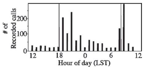
Fascinated by how environmental conditions influence sound, he led interdisciplinary research to study how elephants can communicate using low-frequency, infrasonic calls that can travel for miles.

Through field studies in Etosha National Park, Namibia, Garstang and colleagues showed that temperature inversions and calm nighttime conditions enhance sound transmission, while daytime turbulence weakens it, effectively creating natural “windows” for long-distance communication. Elephants naturally know this and save their long-distance phone calls for these times.2
His work advanced the field by revealing that elephant behavior in his study area differed from that of collared elephants elsewhere and by demonstrating the crucial role of atmospheric conditions in noninvasive acoustic studies of elephant communication.
Dr. Garstang saw meteorology as an interdisciplinary science. Two awards supporting interdisciplinary research in atmospheric science at the University of Virginia have been named after him.
In 2015, he published a book, Elephant Sense and Sensibility: Behavior and Cognition.

We are grateful to Lockheed Martin for a grant to support this newsletter. We acknowledge additional contributions from Chris Nabholz (of the Deep South Weather Brief newsletter).

Our archive of WWAT articles is here.
During the preparation of this work, the author(s) used ChatGPT-5 to copyedit text and summarize technical aspects of the paper. After using this tool, WWAT’s author(s) reviewed and edited the content as needed and take(s) full responsibility for the content of the publication.
Covered in a recent issue here.
Because atmospheric conditions vary locally, elephant behavior patterns like these are also highly localized. Other herds may choose different times of day to communicate, depending on when conditions in their particular area are most favorable for sound transmission.