

Fire Breathing Thunderstorms
As if you needed something else to keep you up at night

Sometimes you run across a word that demands immediate attention. Pyrocumulonimbus is one of those words. I dare you to glance away from it. I couldn’t. Once I saw it in a journal, I knew I needed to write about it.
OK, if you aren’t a weather or science nerd, then you may have yawned and moved on. But then you wouldn’t be reading this far. Thus, I am pretty sure 99% of you agree with me - that’s one cool word.
Or rather, hot, because it involves fire. Specifically, thunderstorms that are made of fire. I’m surprised Stephen King hasn’t written a book about it yet.
From Firestorms to Thunderstorms
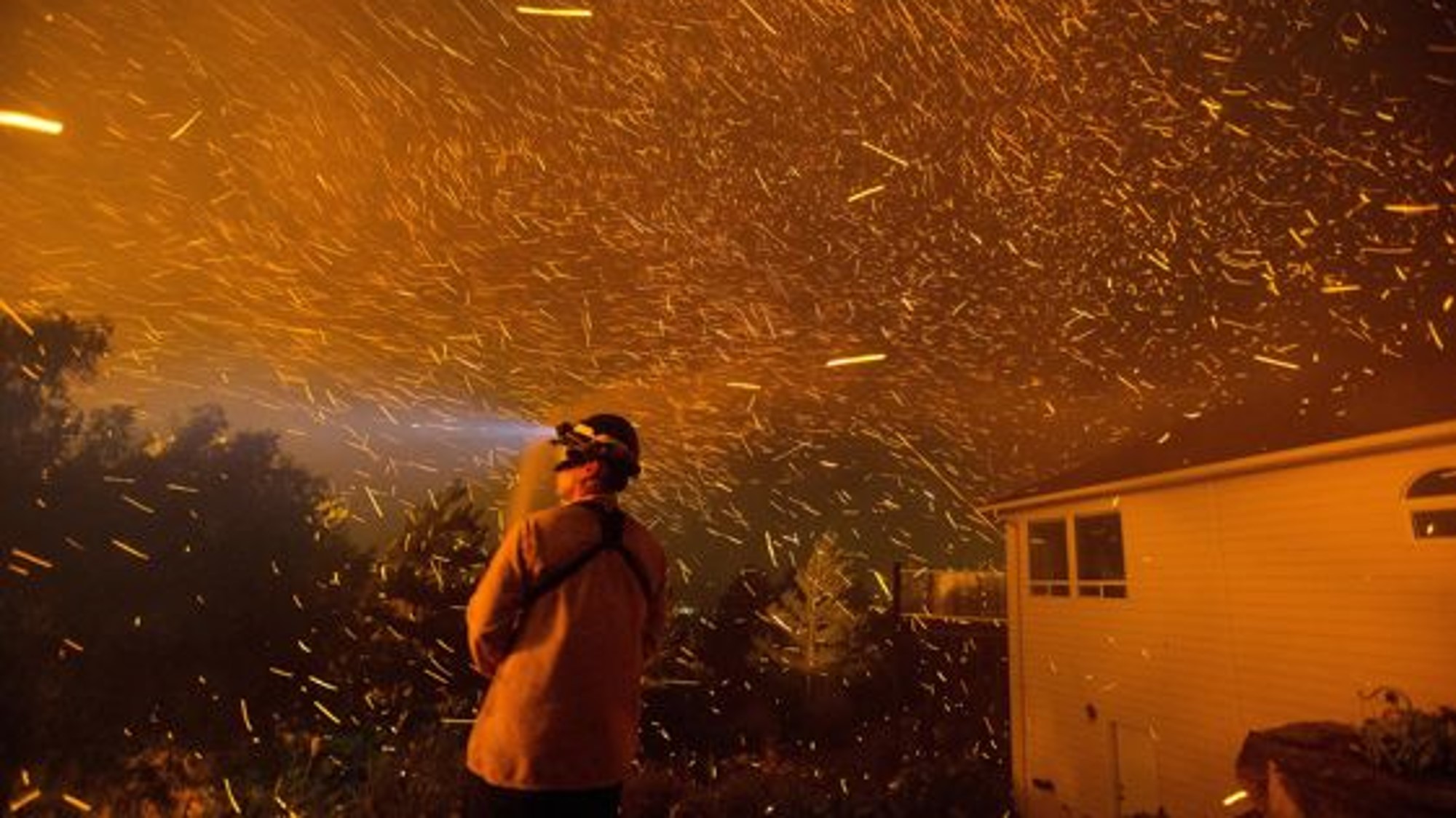
You probably already know about the terrible phenomenon known as firestorms. These occur when a fire becomes so large and hot that it generates its own weather. The heat causes air to rise at a tremendous rate, pulling in air near the surface and creating intense, hot winds. The circulation can also begin to rotate, producing vortices of fire known as firenadoes and their smaller cousins, fire whirls. Firestorms can occur naturally in large wildfires and, sadly and unnaturally, during heavy wartime bombing raids on cities.
If the firestorm is in the right conditions, then it can grow into something even greater - a full-blown thunderstorm with rain, hail, and lightning. Scientifically, they are known as pyrocumulonimbus, or even more scientifically, as pyroCB.
Our tale begins with a gentle firestorm rolling through a forest. If the forest is dry and dense, a little moist, and if the fire is moving slowly, it can pump out smoke as if it’s auditioning for a Cheech ’n Chong movie. This smoke is key to its evolution into a thunderstorm.

The fire’s intense heat drives a powerful updraft that lifts smoke particles high into the atmosphere. Those particles act as condensation and ice nuclei, helping water condense and freeze. This can enhance latent heat release and allow the cloud to glaciate rapidly, building into a deep, thunderstorm-like column. Within that column, collisions among ice and smoke-laden particles promote charge separation and lightning. Now we have the thunder for a thunderstorm.

PyroCbs can produce extreme updrafts and downdrafts dangerous to firefighting aircraft. It can also generate lightning to ignite new fires, hail, ember storms, and fire-generated tornadoes. As if that wasn’t enough, the smoke can sometimes rise into the lower stratosphere, where it can persist for over a year. That stratospheric smoke has been linked to changes in air circulation, ozone chemistry, and Earth’s radiative balance. PyroCBs are likely responsible for up to 25% of the black carbon and organic aerosols in the lower stratosphere.

Detecting pyroCBs
PyroCbs are identified primarily by their distinctive satellite signature. From space, they look like extremely tall, cold-topped thunderstorms growing directly out of intense wildfire plumes. The smoke embedded in the cloud creates unusually small ice particles at the top, which gives the storm a unique fingerprint when satellites view it at multiple infrared wavelengths.

Forecasters combine those cloud-top signals with satellite fire products that measure heat output and active fire locations to confirm that the storm is fire-driven. Detection is increasingly automated using algorithms that scan for these patterns, though analysts still review events to verify that what they’re seeing is truly a pyroCB and not just an ordinary thunderstorm with a smoky van driving through it.

To track wildfires, NASA maintains the MODIS Collection 6 Active Fire (MOD14) database, which records the location and radiative power of individual fire pixels detected by the Aqua and Terra satellites. Also, the Naval Research Laboratory maintains a pyroCB inventory using data from five different satellites covering the Earth. Finally, they included meteorological variables around the fires taken from the GFS database.1 Researchers used this data to look for trends and predictors in pyroCB behavior.

Analyzing pyroCB Patterns
One such team, led by Dr. Evan Krell, set out to better understand the atmospheric and fire conditions that favor pyroCb development and to test whether machine-learning models could detect them. They used those two datasets to train the models with data from 2013-2020. Then they tested the trained models on data from 2021 to see whether they could successfully identify pyroCb events. They published their methods and results in the journal Artificial Intelligence for the Earth Systems.
Most of their results concerned performance differences among different machine learning techniques. But there were some overall results worth reporting:
The models performed well at detecting pyroCBs, but only when using both satellite and atmospheric data. Using either dataset alone was not as accurate. This supported the authors’ thesis that pyroCBs are a complex interaction between fire and a supportive atmospheric environment, so we need to consider both.
Rare/unusual pyroCBs were not well captured. These include events where the atmospheric conditions were different than most of the others (ex: differences in wind shear). This isn’t really a surprise, given that machine learning needs prior data from which to learn. And the events being rare, there simply wasn’t much to train on. As the databases expand over time, the models may improve at detecting these less typical pyroCBs.
Experts are still needed. The models statistically determined the best atmospheric variables used to predict pyroCBs in the 2013-2021 data. However, when tested with the 2021 data, the variables that experienced scientists flagged as important were more useful. In other words, machine learning worked best when guided by meteorological expertise.
There is a consistent trade-off. Tweaking the model to reduce missed pyroCbs often increases false positives. This is a classic forecasting problem, but important because pyroCbs are high-impact yet infrequent. So small failures are quite visible and could lead to low confidence in future forecasts.

PyroCbs are rare events, but their frequency appears to be increasing as human-driven changes in climate and land use alter fire behavior and the environments that support these extreme storms. Research like this helps us better understand the mechanisms behind pyroCbs and, ideally, improve our ability to predict them.
Because most current weather models do not directly integrate detailed fire behavior data with atmospheric data, they are not well-suited to forecasting pyroCbs. The hope is that studies like this will inform more sophisticated, coupled fire–atmosphere models in the future.

And Now for Something Completely Different
We’ve talked in the past about changing climatology and the evolution of where tornadoes are now more likely to occur. NOAA has issued two interesting graphics to illustrate this shift.

The overall pattern remains largely the same, but the region of highest probability has shifted from the central Plains into the upper South. And check out this lucky area!
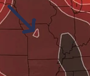
Below is a handy video that shows how the probabilities change daily over the course of a year. A bullseye literally forms over Oklahoma in May. If I were trying to convince someone not to sign with the OKC Thunder, I’d send them this video.
Data for these graphics comes from the NOAA NCEI Storm Events Database.
We acknowledge additional contributions from Dr. Milind Sharma and Chris Nabholz. We are grateful to Lockheed Martin for a grant supporting this newsletter.

Our archive of WWAT articles is here.
During the preparation of this work, the author(s) used ChatGPT-5.2 to copyedit text. WWAT’s author(s) reviewed and edited the content as needed and take(s) full responsibility for the content of the publication.
Weather with a Twist is published by the American Meteorological Society.

NOAA Global Forecast System