

Cloud Drop Size
There's something in them there clouds

The first time I flew into a cloud as a kid, I was surprised to see water forming on the airplane’s windows. Like any young weather nerd, I knew clouds were made of water particles, but I had assumed they were too small to collect like that. After all, I never got soaked walking through fog.1

Of course, the size of the particles had nothing to do with water coating the windows. But it was a striking visual lesson for my younger self: that water in a cloud has mass. It’s real, and it adds up. Suddenly, clouds weren’t just puffy waifs in the sky—they were tangible structures. It was an eye-opening moment and an important part of growing up, like when I realized I’d never be older than my sister2.
Water particles in clouds directly influence things like cloud formation, precipitation, and electrification. Smaller droplets tend to remain suspended longer, contributing to cloud longevity and albedo (portion of sunlight reflected), which affects weather patterns and climate by modifying how sunlight and heat interact with the Earth. Larger droplets typically grow by colliding with and collecting smaller droplets, eventually becoming heavy enough to fall as rain. Using radar, we can measure their sizes (along with shape and orientation) to help distinguish between precipitation types (drizzle, heavy rain, ice, etc.). Additionally, variations in droplet size impact cloud electrification and the development of lightning and thunderstorms.
Broadening of Cloud Droplet Spectra
Cloud droplets first form when water vapor condenses onto aerosol particles in the atmosphere. The sizes of those droplets are influenced by water vapor availability, aerosol concentration and composition, and cloud dynamics. The distribution of the sizes of these droplets is referred to as cloud droplet spectra.
One of those cloud dynamics that influences droplet size is the movement of adiabatic parcels of air. These are theoretical chunks of air that move through the atmosphere without exchanging heat with their surroundings. When such a parcel is rising, it experiences lower air pressure, which allows the parcel to expand. The expansion requires some of the parcel’s internal energy, causing the parcel to cool. This cooling reduces the air's saturation vapor pressure, the maximum pressure that water vapor can exert at a given temperature before condensation starts. The same amount of water vapor in a cooler cloud increases relative humidity and the likelihood of condensation and cloud formation3. It’s the same process used in water-cooling air conditioners commonly found in dry climates.

The problem here is that theory didn’t match observation. The theories explaining this process predict a specific range of droplet sizes which was relatively narrow. However, what scientists actually see in the clouds is different. They see a wider range of particle sizes.
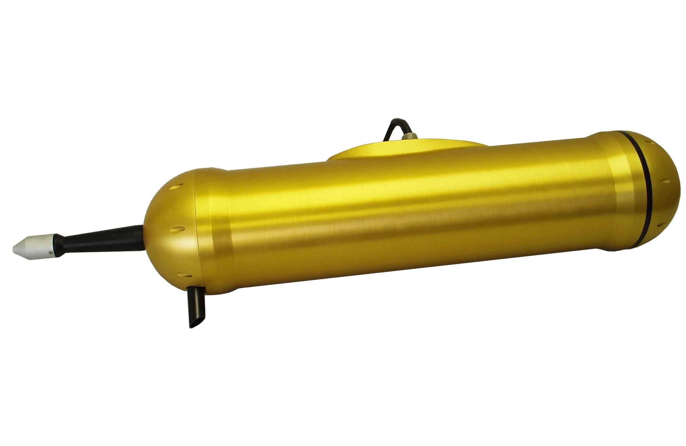
To measure droplet size, aircraft carry instruments which use lasers to illuminate particles passing through a container. One such instrument is the PCASP-100X probe (below):
Many studies over the past few decades have reported a broader range of cloud droplet sizes than predicted by theory4. A wider spectrum can indicate a variety of growth processes within the cloud, such as condensation and collision-coalescence. So understanding this spectra is key to understanding how clouds form.
Eddy Hopping
One possible explanation for the wider droplet size distribution is turbulence in the air parcel. Extra and unpredictable movement impact droplet growth histories, leading to a wider variety of sizes. One of the mechanisms of turbulence is eddy hopping - which is one scientific concept that comes as labeled. Droplets hop from different eddies within the air parcel, this adds increased variation to their growth paths.

However, recent research suggests an important flaw in relying on the eddy hopping mechanism. Earlier models might have overestimated the broadening effect by not adequately accounting for vertical droplet dispersion. Those models considered periodic lateral boundaries, which allows drops to grow (or shrink) indefinitely as long as velocity fluctuations are mostly associated with upward (or downward) movement.
Wojciech W. Grabowski, Senior Scientist Emeritus at the NSF National Center for Atmospheric Research (NCAR), ran new simulation models to correct for that. In the model, he used a stochastic model with idealized simulations to separate the impact of vertical dispersion with eddy-hopping. He recently published the results in the Journal of Atmospheric Sciences and also presented a talk on the subject at a recent NCAR seminar.
His simulations indicate that much of the observed spectral broadening results from the vertical dispersion of droplets. Droplets moving upward encounter higher supersaturation and grow, while those descending evaporate in subsaturated air, naturally widening the spectrum. While eddy hopping and turbulence still play a role, their impact is smaller than previously thought.
Thus, his finding revives the mystery: What is driving the observed local broadening of cloud droplet spectra? Grabowski proposes that complex three-dimensional cloud dynamics may be at play, including environmental conditions at the cloud base, the mixing of drier air from outside the cloud (a.k.a. entrainment), and turbulence on a larger scale. This question has intrigued researchers for over half a century, and the search for answers continues.
And Now for Something Completely Different
Who doesn’t love a good revolving door? It’s cinematic gold.
How about this wonderful scene from the Truman Show where the revolving door symbolizes Truman’s transition from fantasy into reality. Revolving doors are literally a liminal space in life.
And they owe their existence to weather! I live in Chicago, which is apparently the revolving door capital of the United States. It’s also the birthplace of the skyscraper—and the two facts are connected. In very tall buildings, heat rises through elevator shafts and stairwells, creating a draft that pulls in colder air at the bottom. That air has to come from somewhere, and it often rushes in through the ground doors, making them difficult to open and close.
This effect is most pronounced when the temperature difference between the inside and outside is at its greatest. With Chicago’s frigid winters and warm summers, the city experiences some of the largest temperature differentials among major U.S. cities.5 In winter it can be near zero outside and a balmy 75 inside, creating quite a draft. More than once I’ve had trouble opening the door of a Chicago highrise in the winter.

Revolving doors address that by keeping a longer seal between the inside and outside thanks to the additional doors. Click here for details and an interesting story about the history of revolving doors.

We acknowledge additional contributions from Beth Mills and Dr. Milind Sharma.
We are grateful for a grant from Lockheed Martin to support this newsletter.6

During the preparation of this work the author(s) used ChatGPT-4o in order to copy edit text and understand some of the key concepts. After using this tool, the author(s) reviewed and edited the content as needed and take(s) full responsibility for the content of the publication.
But of course I wasn’t walking at 600mph.
This was a traumatic day. I still remember exactly where I was when it happened - angrily pouting behind a set of curtains.
This is just one of many ways clouds are formed.
The effect also occurs in the summer, but it is less extreme as the difference between 75 and 95 is less than 75 and 0. And also people (at least in a temperate place like Chicago) tend to have windows open in the summer, which can mitigate the effect.
This ends our list of footnotes for this issue, which I believe is a record.
Seemingly simple things can be quite complex, from raindrops to puffy clouds
Thanks for the insights Aaron!
A fascinating break down of cloud physics. Its so easy to miss the amazing things happening in our atmosphere. This is a great reminder!