

A Drop in the Ocean
Hurricanes feed on their own rain

As a thought experiment, I’m sometimes wondered how deep you’d have to go in the ocean to essentially escape a hurricane. Do dolphins, sharks, and other sea creatures notice or care at all about hurricanes?
Until now, I had no idea that the thought experiment actually has important implications for hurricane development and strength. It’s a real-life question meteorologists and oceanographers are eager to study. Why? Because there is a feedback loop between hurricanes and ocean surface waters.
Tropical Storms, Hurricanes, Typhoons, Oh My
Allow me a brief moment to discuss the boring world of nomenclature. Like that scene in The Hunt for Red October where the camera zooms in on a sailor’s mouth as he switches from Russian to English, I’m about to change terminology.
Notice that the transition happens on the word “armageddon”, which is the same in both English and Russian. (chef’s kiss)
In North America, we typically use the terms tropical wave, tropical depression, tropical storm, and hurricane to describe different stages of cyclones that form in the tropics. Instead of hurricane, you’ll hear typhoon and in the Indian Ocean and the South Pacific they prefer cyclone. And that’s just in English. Once you start translating across languages, things really spiral.
For the purposes of this newsletter, we’ll use the term tropical cyclone - the umbrella term preferred by meteorologists in scientific literature. It covers all of the above, regardless of what part of the world the storm is in or what it’s called locally.
Tropical Cyclones and the Ocean Surface
One of the main energy sources for a tropical cyclone is heat from the surface of the ocean. As warm air rises from the ocean, it cools and condenses into clouds, releasing heat in the process. This latent heat warms the surrounding air, causing it to rise further and lower surface pressure, which in turn draws in more warm, moist air from the ocean. This creates a self-sustaining feedback loop that powers the tropical cyclone.
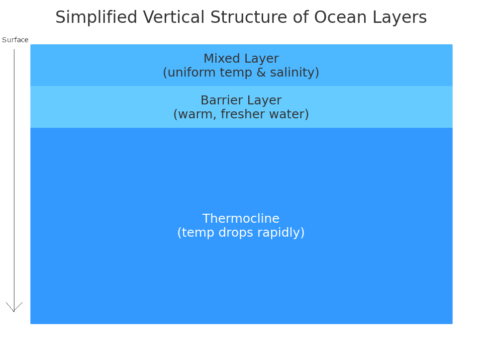
That heat comes from the ocean’s surface, where water is stirred by wind, currents, and jet skis. This top layer is called the mixed layer (ML), and its churning gives it a fairly uniform salinity and temperature. Immediately beneath lies the barrier layer (BL) which, as its name suggests, serves as a barrier between the mixed layer and the layer below - the thermocline (another reference for fans of the HFRO book). The thermocline is the zone where water temperature begins to drop rapidly with depth.

A BL forms when heavy rainfall or river runoff freshens the surface, making it less dense and more resistant to mixing with the cooler, saltier water underneath. It acts as a salinity-driven “floor” beneath the mixed layer. When the BL is thick (>~30m), it can help the ocean’s surface retain heat by limiting the upward mixing of cooler water from below. In a sense, it’s an insulating pad for the ocean’s surface.
Thus, a thicker BL can increase tropical cyclone development.
Those same tropical cyclones are dumping huge amounts of water into the ocean in the form of torrential rain. As freshwater, it has the potential to impact the salinity of the mixed layer which subsequently increases the width of the barrier layer. This preserves surface heat. Thus, a tropical cyclone’s own rain could help strengthen it.
However, there is a lot of water in the ocean. As in, 26,700,000,000,000,000,000,000,000 (267 octillion) raindrops worth. So would even torrential rainfall be enough to have an impact on the ML’s salinity beneath a cyclone?
A research team led by Lianxin Zhang1 recently published a study to answer that question. Using buoy data, they studied how the 2014 Typhoon Kamaegi reshaped barrier layer thickness as it swept across the South China Sea.

Their main sources of data were five moored buoys and four subsurface moorings laid out in the South China Sea. The instruments recorded measures of water temperature, salinity, and pressure every two minutes at depths up to 400m. Variables related to ocean current and near-surface weather conditions from weather satellites and other remote instruments were also included. Together they were able to create temporal and spatial maps that showed the evolution of the barrier layer as the tropical cyclone passed overhead.
Not All Barriers Are the Same
They found two surprising results. First, rainfall created barrier layers much faster than expected - within minutes in the most intense part of the typhoon. In one notable one-hour period, two separate BLs formed minutes apart.
Both of those layers were about the same thickness (~31 m), but their Barrier Layer Potential Energy (BLPE), a measure of how resistant the layer is to mixing, was very different. The first BL, linked to the heaviest rainfall, had nearly four times the potential energy of the second. As a result, it blocked about 91% of mixing-related cooling, while the second peak blocked only 29%. This is likely caused by the heavier rainfall causing greater stratification in the mixing layer.
Second, intensity matters. The right side of northern hemisphere tropical cyclones tend to be the strongest due to the added energy from their forward movement combined with their counterclockwise rotation. They detected this effect in the BL as well. On the right side of the typhoon, ocean cooling from mixing was reduced by 32% overall. On the left it was reduced by 15-19%.
The big takeaways from the study are: 1) tropical cyclone rainfall rates are substantial enough to impact mixed-layer salinity and change barrier layer thickness, and 2) this can happen very quickly. Most forecasts assume gradual changes in ocean temperature as a tropical cyclone passes, so models may need to be updated to be more responsive to this and to use rainfall rates to influence estimated cooling. These are direct, tangible results that should help improve the forecasting of tropical cyclone development.
And to answer the opening question: do dolphins, sharks, and other sea critters care at all about tropical cyclones? Probably not. It’s doubtful they notice the wind, rain, and lightning directly. The water may cool, but probably not enough for them to care. However, there is some evidence they notice (and try to avoid) the additional freshwater that comes from rainfall and shore runoff.
And Now for Something Completely Different
“And the pre-hurricane top-selling item was beer."
Paul Walsh writes a Substack newsletter called G2 Weather Intelligence, which focuses on aspects of weather related to business. In a recent newsletter, he writes about how storm forecasts can drive more business than the storms themselves.
He shares a story from earlier in his career when he tracked where The Weather Channel was deploying its celebrity storm spotters (Jim Cantore, etc.) and would reallocate inventory (such as frozen chickens) accordingly.

He reports that Walmart took it further, using data mining to learn that people in the southeast tend to stockpile Pop-Tarts and beer before storms. On the other hand, I can attest that New Englanders prefer the french toast system (and also, presumably, beer) for hunkering down.
We are grateful to Lockheed Martin for a grant to support this newsletter. We acknowledge additional contributions from Beth Mills, Dr. Milind Sharma, and Chris Nabholz.

Our archive of WWAT articles is here.
During the preparation of this work, the author(s) used ChatGPT-4o in order to copyedit text and create the ocean layer diagram. After using this tool, WWAT’s author(s) reviewed and edited the content as needed and take(s) full responsibility for the content of the publication.

Key Laboratory of State Oceanic Administration for Marine Environmental Information Technology, National Marine Data and Information Service, Ministry of Natural Resources, Tianjin, China.
Beer definitely, if one can keep it cold during the storm . 😱