

Oceanicity
It's about influence

The following is our monthly issue for paid subscribers. WWAT will always remain free, but we do monthly deep dives for those who support us. The AMS is a scientific, non-profit organization, and this is published by its education team. Subscription revenue supports the team and allows us to offer a token honorarium to our scientific reviewers.
A colleague of mine ran across the concept of oceanicity as part of their general duties. They thought it was an interesting idea and shared it with me. And, following the theme of the last issue, I decided to steal it.
Said colleague also offered that they feel claustrophobic when away from the coast. I’m guessing that, to them, watching Dune was like watching Jaws for the rest of us.

Oceanicity describes the extent to which a nearby body of water shapes local climate and weather. Islands are probably the first thing we think about.
-2.jpg")
But the sea can also impact the climate hundreds of miles inland. For example, the Gulf Stream has a huge impact on the weather of northern and western Europe. Without it, London would be almost as cold as Moscow. Below is a map of mean surface temperatures. Notice how much warmer Europe is vs Canada at the same latitude.

It’s largely because of the Gulf Stream, which can be seen in the graphic below. It brings warmer water to the North Atlantic, acting as a hot water bottle for Europe. It’s oceanicity in pretty colors.

The Ingredients of Oceanicity
Ocean temperature is just one part of oceanicity. It mostly depends on being near a large body of water and having a steady wind blowing ashore. Then there is fetch, the uninterrupted stretch of water the wind travels over, picking up energy and water vapor along the way. Other factors matter too, and we will get to them. But distance and wind are the two parents in the front seat, bickering maybe, but directing the show.

The Conrad Index and Continentality
Oceancity has a counterpart known as continentality. That the latter is much better known, despite describing basically the same thing, shows the bias we humans have for land over water. Continentality can be illustrated via a measure known as the Conrad Index of Continentality. Victor Conrad was an Austrian-American meteorologist and seismologist who emigrated to the United States in 1938 to avoid persecution. He formalized the index in 1946 to quantify the oceanic-to-continental spectrum on a scale of 1-100.
The Spots with the Least and Most Oceanicity
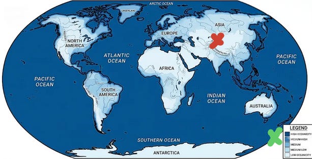
Earth’s most landlocked point is known as the Continental Pole of Inaccessibility, and is located in northwestern China's Xinjiang province. It is positioned an equal distance away from the Arctic Ocean, the Arabian Sea, and the Yellow Sea.
It’s opposite, the point with the highest oceanicity, is likely Campbell Island/Motu Ihupuku, New Zealand. It has a Conrad Index of -5, which is amazing because it means it is more influenced by the ocean than an average spot on the ocean’s surface! This is likely due to influential currents combined with extreme wind. On average, it receives only 1.8 hours of sunshine per day and experiences a wind gust >60 mph about once every three days.
Ocean vs. Lakes
Oceanicity has the word ocean literally embedded in it. And the definition in the AMS Glossary of Meteorology refers strictly to the sea, but the influence of large bodies of water is not restricted to oceans. I live next to a big lake, large enough that you cannot see across it. And that has a tremendous impact on my weather. I can never come to terms with the official NWS readings for Chicago being recorded at an airport 24 miles away from downtown. They are consistently different from what most people in Chicago experience, yet O'Hare is our "official record." This creates all sorts of problems, especially for tourists and people who use automated weather apps that don’t know to account for the lake. I understand why the NWS doesn't want to change it (historical data), but I can still hold a grudge against whoever made that decision. If only they had been educated on oceanicity.

Oceanicity vs. Synchronicity
Water does not just shape climate. It shapes culture. Coastal people navigate by the water. Norwegians have a word, friluftsliv, for their entire outdoor-life philosophy, forged by a coastline so jagged it would take you over 50,000 miles to walk it. The British, parked on an island with maximum oceanicity, turned weather small talk into a national art form. Meanwhile, the people at the Continental Pole of Inaccessibility presumably talk about something else. Sand, maybe.

The most successful of all may be Corona beer. They created a brand associated with a chill-out beach vibe. It’s been so successful that Corona is now the most valuable beer brand in the world.

I wouldn’t mind a piece of that billion-dollar pie…

Coming Soon: Weather With a Twist of Lime.
Our archive of WWAT articles is here.
During the preparation of this work, the author(s) used Claude Sonnet 4.6 to copyedit and fact-check and Gemini 3.5 Flash to generate the oceanicity map which was then edited. WWAT’s author(s) reviewed and edited the content as needed and take(s) full responsibility for the content of the publication.
Weather with a Twist is published by the American Meteorological Society.