Few things have revolutionized meteorology as much as satellite technology. In fact, their impact can be compared to the automobile revolution caused by the Chevy Geo. The world of trucks was never the same.

It started modest enough. But like a Pokemon touching the monolith, the Geo evolved into something out of this world:
The speedometer goes to 300.
Weather satellites also evolve, if less flamboyantly. Some would argue the first dedicated weather satellite photo was this:
There is a certain vintage grandeur to it, to be sure. But compare it to this one from a few nights ago:
The more recent image was captured by the GOES-East weather satellite, which is operated by NOAA and was constructed by Lockheed Martin. “GOES-East" serves as a collective name for a series of satellites positioned over eastern North America. Similar to the transitions seen in Doctor Who, these satellites are periodically replaced with newer models, each maintaining the same core mission but with unique characteristics. Currently, the GOES-16 satellite fulfills this role. It is scheduled to be replaced by the GOES-19 satellite, which has already been launched and is currently being tested and calibrated while in orbit.
GOES-19 is expected to remain operational for the next decade. However, constructing a satellite of this caliber and importance takes time. Consequently, planning for the next generation is already well underway. In 2018 and 2020, NOAA released reports with recommendations for this forthcoming generation of satellites, which are expected to operate for over 20 years. Therefore, scientists and engineers must carefully consider what weather forecasting will entail in the 2050s!
Geostationary Extended Observations (GeoXO)
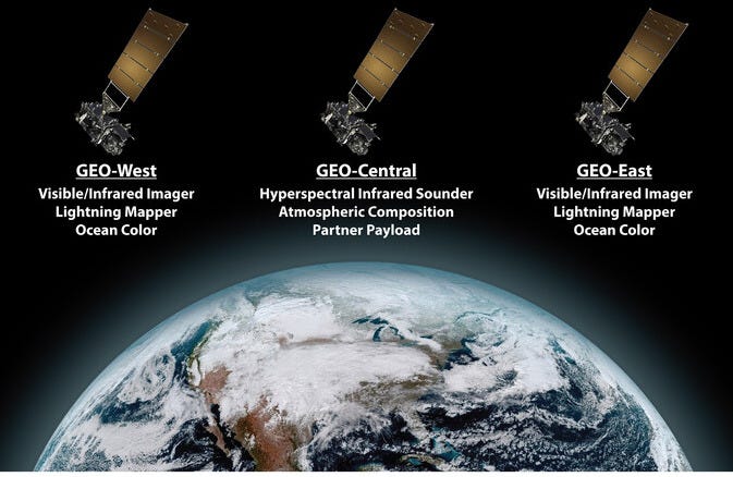
The new system of satellites has been given the name GeoXO, short for Geostationary Extended Observations. Two satellite models will be developed - Geo-L and Geo-S. The Geo-L model will replace the current GOES-West and GOES-East satellites. The Geo-S model will be sandwiched in between them. There will be an on-orbit spare for each, meaning when all is said and done, there will be six GeoXO satellites in orbit.

Recently, scientists and engineers at NOAA and NASA published a paper in the Bulletin of the American Meteorological Society describing the instruments that will be aboard the two spacecraft models. They are:
Geo-L
Pretty Pictures: The GOES satellites currently take awesome images across a wide spectrum. The committees decided that increasing spatial resolution would be more important than adding new spectral bands. They want to double the resolution by 4, leading to resolution down to 1/4 km under ideal circumstances. That’s the length of three football fields. And this would be from an orbit about 36,000km (22,000 miles) away!
Lightning: The current GOES satellites carry a Geostationary Lightning Mapper, which we previously talked about here. An upgraded version is proposed with improved resolution and sensitivity due to a transition from CCD (Charge-Coupled Device) to CMOS (Complementary Metal-Oxide-Semiconductor) cameras. CMOS features faster processing speeds and lower consumption of power, which is as precious as gold on a spacecraft.
Another important improvement will be a larger field of view, finally allowing higher-resolution imagery of all of Alaska. Sadly, Alaska is currently relegated to the edges of the GOES fields of view (fov) - where the data quality and resolution is not as good as the center.
Currently, 1 km pixel covers an approximate geographic area of around 4 km over southern Alaska and up to to 8+ km over northern Alaska. Notice more cloud detail in the southern regions vs. the northern regions. See the Satellite Liason Blog for a nice explanation. (NOAA) Ocean Color: Currently, ocean color sensors are only aboard low-Earth orbiting satellites, which usually pass over a given point in the ocean only a few times per day. However, due to cloud cover, sun reflection, and other interference, only one or two high-quality data points per week end up being available for some locations. A geostationary satellite will provide nearly continuous coverage.
Geo-S
Layers of the Atmosphere: The Hyperspectral Infrared Sounder (IRS) is an instrument designed to measure temperature and moisture at various atmospheric levels. These variables are crucial for long-term computer models and short-term forecasting (nowcasting). Similar to the ocean color instrument, this will be the first of its kind in a geostationary orbit, allowing for near-hourly observations.
Air Quality: The Korean Aerospace Research Institute and NASA recently collaborated to develop and test satellite instruments that monitor air quality and atmospheric chemistry. A next-generation version of this technology will build on their success and could be used to track wildfire smoke, chemical explosions, fine particulate air pollution, and more. This technology will be instrumental in assessing the effectiveness of various environmental policies.
Pot Luck: A slot for a "partner payload instrument" has been reserved for an as-yet-undetermined instrument. This could accommodate a brand-new instrument still under development or enable a partner agency to contribute to and support the project. Such flexibility is essential for a project expected to remain active for decades.
Real World Meaning
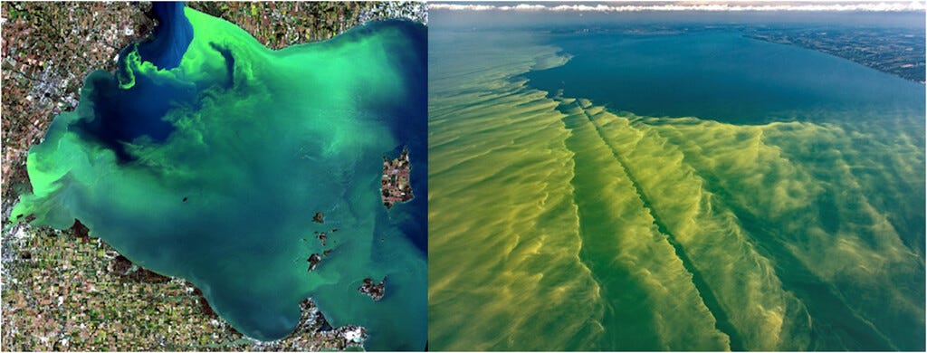
Improvements in these instruments will benefit scientists, forecasters, government agencies, and private sector industries alike. For example, the Ocean Color Instrument (OCX) will monitor phenomena such as cyanobacteria blooms in Lake Erie. Its more frequent data collection and higher resolution will enhance the ability to predict when toxic algae blooms may approach beaches or water sources. This capability has significant implications for public water agencies as well as the fishing, recreation, and tourism industries.

The first GeoXO satellite is planned for launch in the early 2030s. But lots of work has to be done before now and then. Past GOES satellites were designed to last about a decade, while these must last three times as long. This means additional testing and design needs to be done to make sure they can survive the harsh environment of space. The journey to space has to start somewhere, and now they have a plan.
And Now for Something Kinda Different
The Earth isn’t the only planet with weather satellites. One of the primary missions of the Mars Reconnaissance Orbiter (MRO) is to observe its climate with a focus on atmospheric circulation and seasonal variations. Using MRO data, Malin Space Systems published a weekly Mars weather report from 2007 - 2022.
The hot topic in Martian weather is dust, dust, dust. Because that’s what it’s like on Mars. Although clouds of water and carbon dioxide ice will occasionally make an appearance, giant planetary-wide dust storms are the name of the game.
NASA/JPL’s Martian rovers, currently named Curiosity and Perseverance, also carry instruments to measure surface humidity, pressure, temperatures, wind speeds, and UV radiation. While the average surface temperature of Mars is a frigid -80°F (-60°C), it can get as warm as 60°F (20°C) at the equator in Martian summer. However, even a balmy day like that will lead to an evening temp usually below -100°F (-73°C).
Here is more about the weather on other planets.
We acknowledge Beth Mills for additional contributions.


Nuts! In my e-mail I said the Geo was from Ford, when it was made by Chevrolet. I updated the web version.