

CAPE Shear
It's hard to study a quasi-storm

The prefix quasi- is kind of a weasel word in the sciences. When one isn’t quite sure if something qualifies as a thing, but it’s a close call, you can throw quasi- at the front of it and get the best of both words. It’s like a scientific shrug.

I’m guilty of doing it myself. In a past life, I was looking for a rhythm in the fluctuations of a particular star’s brightness. I didn’t find what I was looking for. But I found something else that could be related. So I added quasi- to it, got published, and got a pat on the back from my professor. Then the world quickly forgot it. It was a quasi-success.

Quasi-Linear Convective Systems
Meteorology has its own quasi’s. It’s a favorite because the atmosphere rarely behaves in a perfectly pure way. It essentially means "seemingly" or "to a certain degree”. The official AMS Glossary of Meteorology includes 18 terms that start with quasi-.

But for most of us, the most interesting meteorological quasi- are Quasi-Linear Convective Systems (QLCSs)1. They are lines of thunderstorms with embedded rotating circulations that grow, fade, merge, and separate as the line progresses. While flooding and straight-line winds are the most common dangers, about 10–20% of all tornadoes form within them. They tend to be less intense than tornadoes born in supercells… but they are still tornadoes, with all that comes with that.
While a QLCS can form in any season, they tend to peak in April - July. Those that form overnight and during the cooler months (late fall through early spring), however, are more likely to include tornadoes. In contrast, supercell tornadoes are more likely in April-June. QLCS tornadoes tend to be found at the northern end of the QLCS and several hours after the system itself has formed. The large-scale conditions that favor QLCS formation are well studied, as are the internal dynamics within a QLCS as tornadoes develop. What has not been studied as thoroughly are the conditions immediately surrounding the QLCS after it has formed, but before tornadoes begin.
CAPE & Shear
Researchers at North Carolina State University and the NOAA/NWS Storm Prediction Center set out to look for differences in their environments that could help forecasters identify tornadic and non-tornadic storm formation in QLCSs. They recently published their study in the journal Weather and Forecasting.
Two of the most important ingredients for severe thunderstorm formation are instability and wind shear. Instability is measured by a quantity called Convective Available Potential Energy (CAPE). It is how much energy is available to raise a parcel of warm, moist air upward (a.k.a. buoyancy). The higher the CAPE, the more vigorously air will rise once it gets going, and the more explosive storm growth tends to be. Wind shear is the change in wind speed and direction with height. It gives storms their rotation and organizational structure (and produces a lot of the turbulence felt when flying in bad weather). Without shear, storm updrafts tend to be short-lived and disorganized.

High-shear, high-CAPE (HSHC) environments typically produce the supercell storms we know and love. But High-shear, low-CAPE (HSLC) environments, by contrast, present some of the most difficult operational forecasting challenges. They're associated with higher false alarm rates and lower probabilities of detection. The authors of the study suggest studying how shear and CAPE change immediately along the path of the QLCS may help us understand them more.
HRRRRRRRRRRRRRRRRRRRRs
The authors used data from the operational High-Resolution Rapid Refresh (HRRR) model for 79 QLCS events spanning 1,257 case hours between July 2018 and May 2023. The HRRR is a well-respected computer model for forecasting storms on short time scales in North America (hours to a few days). Its hourly update cycle and fine grid spacing make it the best available tool for the kind of analysis they were doing.
Cases were identified using the Storm Prediction Center’s severe weather archive, filtered to events in Louisiana, Alabama, Mississippi, Arkansas, Tennessee, and Missouri - because those areas are more sensitive to damage from QLCSs.2 To qualify, a QLCS had to maintain a quasi-linear reflectivity structure of at least 100 km for at least 3 hours.
To make sure they were studying the right kind of storms, the researchers required that a meaningful portion of the environment around each storm have low energy for storm formation, combined with strong wind shear. They set the bar for "low energy" a bit higher than some prior studies since the Southeast naturally tends to have more atmospheric instability than regions farther north.3

A key methodological contribution of the paper is the QLCS-relative coordinate system. The authors normalized the QLCSs by mapping each one along two axes: how far a point was from one end of the convective line to the other (expressed as a percentage, called the Line Length Percentile), and how far ahead of the line it was. This allowed them to combine all 79 systems into a common spatial framework regardless of each line's length, orientation, or geographic location. They then examined HRRR output conditions across this grid for each case hour throughout the full duration of every event.
Results
First, they found that CAPE varied significantly within the QLCS, largely due to the system’s own influence. Consequently, even if a QLCS begins in a low-CAPE environment, it may transition out of it over time, particularly at the southern end of the line. A QLCS can generate its own low-level potential vorticity (a measure of the circulation or spin of an air parcel) through latent heat release. Within the intense updrafts of the storm, water vapor condenses and releases heat, typically peaking in the mid-levels of the atmosphere. This enhances the low-level jet and wind shear just ahead of the storm, making it more tornado-friendly. However, they found tornadoes are still more likely to the north because, among other things,4 shear is more important than CAPE. The northern end may have less CAPE, but it has enough, and its shear advantage appears to be the deciding factor.
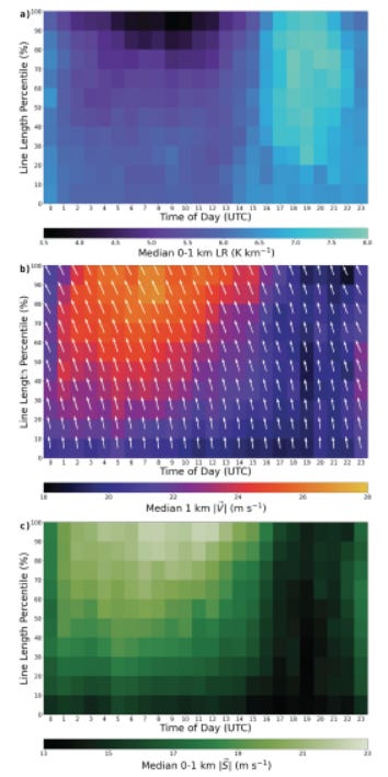
They also found that overnight hours are particularly dangerous. As the boundary layer (atmosphere just above the surface) stabilizes after sunset, low-level wind shear increases substantially. This happens because winds near and above the top of the boundary layer can still be strong, leading to greater contrast with height. And this effect is strongest at the northern end of the line, away from the moderating influence of the Gulf of Mexico.
The paper's core contribution is demonstrating that HSLC QLCS environments are not static. There are systematic gradients along the convective line and ahead of it, and the systems themselves modify their environments in ways that feed back on tornado production. For operational meteorologists, the practical punchline is that proximity soundings sampled well ahead of a QLCS may significantly underrepresent the shear and instability found near the convective line itself. More rapidly updating observational data and computer models would be helpful.
And Now for Something Completely Different
Mike Trout is one of the best baseball players of all time. He’s also a fellow weather geek/nerd/enthusiast. Here he is calling into The Weather Channel (during the off-season!) with a report from a DC blizzard.
He proposed to his wife with an aircraft skywriting the proposal (awwww). But things didn’t go as planned:
“In summer 2016, Trout planned to propose to his longtime girlfriend, Jessica Cox, via skywriting. A plane would write the message in the air — “Will you marry me, Jess?” — while the two of them had lunch at the beach. However, Trout got the forecast wrong, and the planes had to be called off and rescheduled for a break in the weather.” - The Athletic/NYTimes
Nature doesn’t care if you are worth over $140 million. I think that story, officially, makes him one of us.
We acknowledge additional contributions from Beth Mills and Chris Nabholz. We are grateful to Lockheed Martin for a grant supporting this newsletter.

Our archive of WWAT articles is here.
During the preparation of this work, the author(s) used Claude Sonnet 4.3 to copyedit and fact-check. WWAT’s author(s) reviewed and edited the content as needed and take(s) full responsibility for the content of the publication.
Weather with a Twist is published by the American Meteorological Society.
Sometimes people refer to them as squall lines. But to meteorologists, squall lines can be a part of a QLCS, but not all QLCS have squall lines.
Due to population density and the fact that they tend to occur at night in that region.
You can mostly thank the Gulf of Mexico for that. It pumps in enough warm humid air to keep things disorganized. Moist air is less dense, so it has greater buoyancy and rises more quickly, releasing latent heat as the water vapor condenses.
Also because cyclonic vorticity is more naturally present there.
Ontario Specials. We’re known for them.